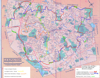
So far I have used relatively low-tech tools just to get the concept out of my head and onto a shareable medium. I scanned a nice map (which shows most of the Lexington conservation lands as well as the roads) from the Community Phonebook Company into a bitmap file, and used Microsoft Paint to draw the trails, along with some alternative routes. Saving the bitmap file as jpeg makes it small enough to email (one meg instead of six). However, I'm doing all the editing work on the bitmap file, since it preserves the quality better than jpeg.
Okay, enough talking... here's the current map, version 1.92:

It's been updated to show the entrance from Laconia Street into the Lower Vine Brook conservation land. Thanks to the local residents who pointed it out to me!
If you're interested, you may want to save the image on your computer and print it out.
I think the key blocks are somewhat self-explanatory, but post a reply here if you have some questions.
Condition of the Loop
Many of these trails are ROUGH. Some barely exist, especially when the weeds and brush grow during the spring and summer. If you are interested in helping to keep the existing trails open, please contact the Steward for the area to get permission.
The segments marked in green on the map are barely-existent (or even non-existent), or cross private land, or both. Don't expect to ride those sections, although you might be able to pass through on foot.
For bicyclists, note that all of the trails in Lexington are for use at your own risk. You are responsible for knowing what is rideable for yourself at your own skill level. There are numerous sections where it may be safest to dismount and walk. And remember, any walkers or horseback riders have the right-of-way.

1 comment:
Interesting to take a current (2017) look at this map. Several of the "lime" (not yet in place) links are now open trails.
- There is a good trail from Hartwell Avenue into the Katahdin Woods/Tophet Swamp area. And also well-marked bike lanes along the pavement of Hartwell Ave.
- There is a well-marked trail (part of "Across Lexington" - route G, I think) connecting the low end of Shade Street with the high point on Spring Street. (Near the other end of Shade St.)
- But the main missing link between Woburn St. and Winchester Drive across the old Winning Farm land is still up in the air, with new construction on the Woburn side and stalled construction on the Winchester side.
Post a Comment